Arkadiusz
Kasprowskich
Szwajcaria
Ubezpieczenia
Temat: K jak Kandersteg

Kandersteg Szwajcaria
Kandersteg is a municipality in the Frutigen-Niedersimmental administrative district in the canton of Bern in Switzerland. It is located along the valley of the River Kander, west of the Jungfrau massif. It is noted for its spectacular mountain scenery and sylvan alpine landscapes. Tourism is a very significant part of its economic life today. It is a year round outdoors mecca for hiking trails and mountain climbing as well as downhill and cross-country skiing.
Kandersteg is located on the northern side of the Bernese Alps at an altitude of 1200 metres above sea level at the foot of the Lötschen and Gemmi Passes. The village, consisting of 1200 inhabitants, lies in the upper Kander Valley. The municipality extends on a territory encompassing the valleys of Gastern (upper Kander Valley) and Oeschinen. It includes the villages of Kandersteg and Gastern.[3]
Kandersteg is surrounded by high mountains. The Balmhorn (3,698 metres), bordering the canton of Valais on the south, is the highest in the valley; it is followed by the Blüemlisalp (3,663 metres), east of the village. The Gross Lohner (3,049 metres) is the highest summit between the Kander Valley and the valley of Adelboden on the west. The Hohtürli pass (2,778 metres) on the east connects Kandersteg to Griesalp in the Kiental valley.
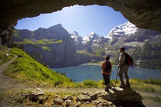
The largest lake in the valley is lake Oeschinen. It is located at 1,578 metres east of Kandersteg, at the foot of the Blüemlisalp massif. The Gastern Valley is an almost closed off valley. At the upper end of the valley lies the Kander Glacier, the source of the 44 km (27 mi) long Kander river. The Gastern Valley is on the way to the 2,700 metres high Lötschen Pass.
Part of the municipality is located within the Jungrau-Aletsch area, declared a UNESCO World Heritage Site in 2001 and extended in 2007. The area comprises Lake Oeschinen and the Gastern Valley. (via Wikipedia)
 пропозиції роботи


